Can you imagine driving places without Google Maps or Waze? Not anymore!. Space is no different. One of the critical elements for human presence in space is the ability to position ourselves (including our spacecrafts) relative to other things. Positioning, Navigation and Timing (PNT) are foundational features of any space network.
Think about the Moon. Due to the homogeneity of its features and colors, visual references have proven not good enough to perform Extra Vehicular Activities (EVA). For example, on Apollo 14 EVA 2 (1971), the crew got lost when trying to reach the rim of Cone crater and had to return to save oxygen and supplies to return to the lander. Later, high-res satellite pictures revealed they were within 30 yards of the rim!. It is common jargon to say "everything in space is trying to kill you". Getting lost in space is definitively one of them. For this reason, LunaNet, NASA's network architecture for the Moon, will provide Positioning, Navigation and Timing (PNT) services to its users.
- Positioning is the ability to determine one's location two or three dimensionally referred to a standard system. Terrestrial coordinates are a good example of positioning.
- Navigation is the ability to determine current and desired position and apply corrections to course, orientation and speed to attain a desired position.
- Timing is the ability to acquire and maintain accurate and precise time (typically Coordinated Universal Time, i.e. UTC).
On Earth, systems rely on global satellite networks known as Global Navigation Satellite Systems (GNSS) for PNT purposes. The following systems are example of GNSS: USA Global Positioning System (GPS), Europe's Galileo, Russia GLONASS and China's BeiDou. As the term "global" may indicate, these systems provide global coverage, there are other systems providing PNT services (typically for augmentation) at a regional level.
With GPS, each satellite transmits a specific signal the receiver (e.g. in your cellphone) is able to compute its time difference between the time the signal was sent by the satellite, and the time it was received. Since this calculation is based on time, GPS satellite time is driven by high accuracy clocks (i.e. atomic clocks). In addition to the time information, the broadcasted signal also contains data that allows the receiver to calculate the position of the satellite and other adjustments needed for accurate positioning. With this, the receiver can calculate the range (distance) from each satellite, and with enough satellites in range (min. four), then computes its own location, i.e. longitude, latitude, altitude and time.
What about space? To answer this question, we need to separate space in layers (spheres), let's say low-Earth orbit, near Earth (aka space service volume), and deep space.
Elements and systems in Low-Earth Orbit (e.g. the International Space Station) can still rely on GPS and similar systems for PNT, pretty much the same way as we do on Earth.
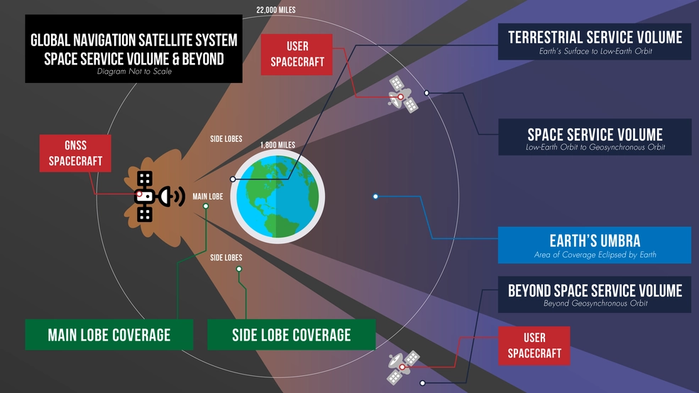
Picture. Different areas of GNSS coverage. Property of NASA.
Beyond Low-Earth Orbit (above 1860 miles according to NASA), to the volume known as Space Service Volume (LEO to GEO), and soon all the way to the Moon, spacecrafts would use specialized equipment and expanded signals from the GNSS systems for PNT. Consider Medium-Earth orbit (MEO) and geostationary GNSS satellites reside at max. 36.000 Km (or 22.000 miles approx.), so in principle anything above that altitude would not be able to leverage GNSS constellations for PNT. However, NASA and other agencies have been working to extend this range by taking advantage of a radiation pattern effect, the side lobe coverage:
- The Magnetospheric Multiscale (MMS) mission recorded GPS-based altitude at 116,300 miles from Earth, which is practically half the distance to the Moon.
- Adding to the data collected by the GARISS instrument (GPS and Galileo Receiver for the International Space Station), NASA Glenn Spaceflight Center and Ohio University developed and launched Bobcat-1 CubeSat in October 2020, to analyze time differences between different GNSS constellations and gather data and improve space receivers' performance.
- Simulations run by NASA suggested the possibility to use GPS in the Lunar Surface and the Lunar Gateway. Now, and in partnership with the Italian Space Agency, NASA is developing the Lunar GNSS Receiver Experiment (LuGRE), a commercial payload GNSS receiver (working with both GPS and Galileo) with plans to deploy it and have the first GNSS-fix on the Moon by 2023.
PNT for Deep Space. We have been tracking Voyager-1 (and 2) since 1977 (they are currently in Interstellar Space) which means these spacecrafts have been able to do PNT successfully. How? Through probably the most elegant features of electromagnetic theory: The use of ranging and the doppler effect. Without entering into much detail (if you would like to get to the bottom of it, I recommend to read JPL/NASA Deep Space Telecommunications Systems Engineering , start page 123), a ground station is able to determine range, position, direction and velocity by doing two-way tracking. i.e. send a signal (from the Deep Space ground network) to the spacecraft, then the spacecraft would return the same signal (as received) to the ground station, and then the ground station would be able to determine the differences (amplitude, phase and doppler) to effectively derive distance, position and direction. After that, the ground station would then send commands to the spacecraft, e.g. for course correction. In this case:
- The ground station would need to "wait" for the receiving signal from the spacecraft. Note there are only three antennas (as part of the Deep Space Network) capable of "talking" to Voyager as example. This means one antenna can only track one spacecraft at a time (scalability problem).
- The deep space ground station carries a very accurate atomic clock. Given the fact that clocks in the spacecrafts are less accurate (due to Size, Weight, and Power considerations), two-way ranging is required.
In order to make this process more efficient, allowing for one-way ranging (i.e. only need to receive a reference signal from the ground station to do PNT), and (more) autonomous navigation, JPL/NASA worked on a prototype Deep Space Atomic Clock (DSAC), which provides for a clock with accuracy better than 2 nano seconds (or 1 second off in 10 million years), 50 times more accurate than those on the GPS system. DSAC is the size of 4 toasters, relatively small when compared with the ground station atomic clocks, typically the size of a refrigerator.
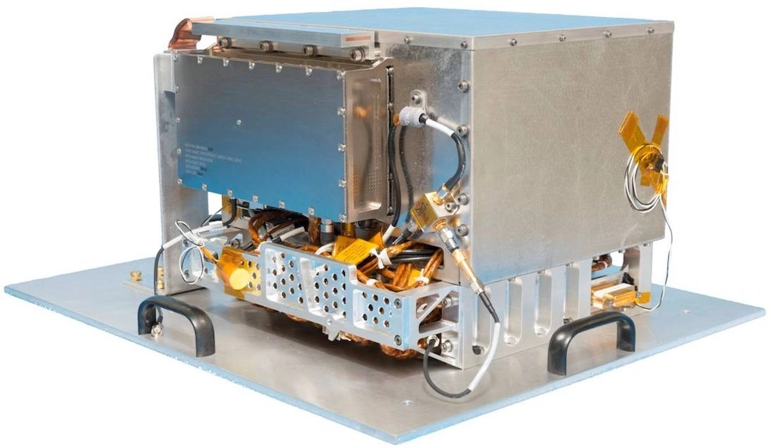
Picture. The Deep Space Atomic Clock ready to get into space. Property of JPL/NASA.
One-way tracking (from Earth to spacecraft) is one good step towards autonomous PNT in deep space, but not the last one. NASA have been researching on a galactic positioning system. This system is based on X-Ray ultra-regular oscillations (radiation) coming from distant millisecond pulsars (MSP) neutron stars to derive timing and location. Pulsars's position are well known by observations, so it is possible to perform, much like GPS on Earth, the trilateration to obtain the spacecraft position. NASA's Station Explorer for X-ray Timing and Navigation Technology (SEXTANT) experiment on the ISS in 2018 demonstrated the potential of this technology.
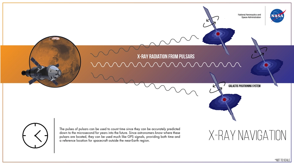
Picture. Infographic of X-Ray Navigation for deep space. From NASA.
What else is happening for PNT in space?
The commercialization of space is bringing many new satellites in (primarily LEO) orbit. Telecommunications and regional PNT satellites also require accurate clocks to provide better positioning accuracy than GNSS. Research and commercial activities are ongoing to provide alternative clocks that can achieve good accuracy at lower cost. Over time, I expect this to impact space PNT activities on the Moon as well as commercial satellites make their way to the Moon.
Optical Navigation is another area that is progressing thanks to the advancements of sensor and computer vision (AI) technologies. This navigation relies on images from cameras on the spacecraft. This includes star-based navigation (using the star position as reference), planetary limb navigation (as the spacecraft approaches the celestial body), and Terrain Relative Navigation (Mars Perseverance real-time landing site selection is a good example of Terrain Relative Navigation).
This article has been written to highlight one of the key features of the upcoming LunaNet, the provisioning of PNT services to the Moon